Hi, my name is Evan and I am one of the interns at CRWA this
summer. I am currently working with GIS (Geographic
Information System), focusing on land use of the lower basin of the Charles
River watershed. I have been focusing mainly
on the Faneuil Brook subwatershed in order to determine the types of land use, such
as commercial, high density residential, forest, and golf course. All of these areas are segregated in a map
which has been analyzed with information, such as the area and the percentage
of the area to the total watershed area.
Outside of the office, I investigated the subwatershed for
pollution and sediment deposits that could end up in the Charles River. A growing concern in the river is a sandbar
that is forming and growing near an outfall from Faneuil Brook. I went into the field yesterday in order to
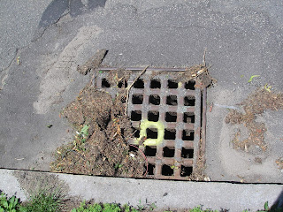
attempt to establish any major sources of pollution or sediment deposits. Driving down the streets, I took pictures of sites
that may be improved or be a source of pollution. Fortunately, I did not find any major sources
of pollution or what could be supplying additional sediment to the sandbar;
unfortunately, I could not find a cause of the deposition for us to implement strategies
in order to stop from continuing.
But the trip was a good adventure and with a manual in hand, the Unified
Subwatershed and Site Reconnaissance: A User’s Manual, I was able to gather
data that can be analyzed further.
 |
| A storm drain with some blockage from natural matter. |
No comments:
Post a Comment