Friday, June 7, 2013

Bioretentions

Last week I had a great opportunity to do some interesting and fun field work for CRWA. I was working with one other fellow intern on this task. The task was to take some photos and videos of some of the project and research sites that CRWA is working on.  By using the photos and videos they would have a better understanding of its progress and study it better.

One of the locations that we had to take some photos was in Blackstone.  The task we had to do was to take some photos of some rain gardens also known as bioretention located at a site in Blackstone. Basically creating a rain gardens turns the impervious surface into a useful previous surface that benefits both the environment and the people. The goal of the rain garden is to fundamentally collect and filter storm water runoff. Photos below are some actual photos of the rain garden located at Blackstone.


Bioretentions are basically made up of layers of mulch, soil and some vegetation or plat roots. The design of the different layers is to help filter pollutants such as bacteria, nitrogen, phosphorus, oil and ect… that could possible pollute our water source.Therefore, it plays a major role in keeping our surface and groundwater safe from pollution. Shown below is a example of a diagram of Bioretention that CRWA is interested in.


Figure 1.3 (An example of a Bioretentaion diagram that CRWA is interested in working on http://www.crwa.org/pubs/StormwaterTreesUrbanEnvMar09.pdf)

Bioretentions can also be a good solution to heavily industrialized city’s such as Boston to keep our streets still green. It can act as a filter sources mainly for the storm water runoff which in return helps the groundwater.  It can also be a filter sources to keep our surface water clean by absorbing all the chemicals on the surface and letting the clean water to runoff to the nearby water source. For more information please visit (http://www.crwa.org/projects/everett_greenstreet.html#phase1).


Mythu

Wednesday, June 5, 2013

Why Dam Removal Is An Important Issue For All Watersheds

I happened across a National Geographic article from mid-May that celebrated the removal of 65 dams on American rivers in 2012. I was surprised to read that 9 of those dam removals occurred in Massachusetts, because I have associated major dam removal projects and controversy with the Pacific Northwest, not New England. Many of the dams removed, such as the Bartlett Rod Shop Co. Dam on Amethyst Brook in Massachusetts, were obsolete and posed a public safety threat. In these cases, I want to applaud the agencies responsible for successfully and safely accomplishing a step toward river and watershed restoration in their communities. However, I think that dam removal is an important policy issue for all American river watersheds because our nation's dams are aging, and while the many long term benefits of removal have been discussed, little is known about the negative effects of removal on the surrounding ecosystem. 

It is not surprising that the general public perceives dams as permanent structures. After all, it is difficult to imagine that the Hoover Dam could be anything but eternal in all its concrete enormity. However, the function of dams is to impede water, the universal solvent. Therefore, dams by definition have an expiration date; their structural integrity breaks down over time as a result of interacting with water. As these structures approach this date, agencies responsible for dam management are faced with the challenge of enforcing regulations and policies to ensure that the safety and viability of surrounding communities and ecosystems are maintained. Dam removal is a management tool to this end.
Removal of the Glines Canyon Dam on the Elwha River in Washington State
Courtesy of http://www.realscience.us/2012/07/12/fish-swim-free-in-elwha-after-dam-comes-down/

However, the practice of dam removal is too poorly understood to be considered the best or only option for the management of aging dams. Of the 75,000 dams that have been constructed on American rivers, only 500 have been removed (Gregory, 2005). Until the ecological effects of dam removal are better documented and analyzed, alternative management strategies must be equally considered. These alternatives include structural repair, changes to dam operation, or even no action at all (Hart, 2002). Although repairing or altering dams is often considered costly, these strategies should not always be replaced by dam removal. The concept of taking no action at all may seem negligent, but dams and their potential removal vary greatly in circumstance and risk. These circumstances are determined by the infinite physical parameters governing watershed systems, and so the risk a dam poses must be considered on a case‐by‐case basis. Instead of encouraging a political climate that either condemns or blindly accepts dam removal as a management strategy, relevant agencies and governments should work to develop policies that will outline systematic decision-­‐making schemes, as well as encourage scientific understanding of the subject by setting standards for analysis and study.
Mass transport of sediment is a consequence of large dam removals, and one of many concerns  biologists have about dam removal, since the sediment contributes to turbidity and can ruin spawning grounds for anadromous species of fish. The above photo shows the sediment plume into the Juan de Fuca Strait following the removal of the Glines Canyon Dam.

During the first half of the 20th century, the United States experienced an era of dam construction in response to increasing demands for energy and water resources fueled by population growth. Legislation such as the Flood Control Act that was passed by Congress in 1927 contributed to a political and social climate that made dam construction an ideal and worthwhile investment (Doyle, 2003). Indeed, dams and their reservoirs successfully provided a variety of services crucial to the nation’s development, such as hydroelectric power generation, irrigation for agriculture, flood control, water storage, and recreation. However, the physical nature of dams interacting with water flows over time diminishes their economic viability and functionality. These structures have a life span between 50-­100 years (Gosnell, 2010), and the choice between relicensing, decommissioning, upgrading, or removing aging dams is becoming crucial to successful watershed management. Furthermore, the political and social climate has begun to change again. Legislation such as the Endangered Species Act puts more pressure on agencies involved in dam management, such as the Federal Energy Regulatory Commission, to force dam owners applying for license renewal to comply with stricter regulations by implementing expensive mitigation strategies.

Unfortunately, the practice of dam removal brings uncertainties into the picture due to its relatively rapid emergence in water management. Over 500 dams were removed in the United States during the past 20 years alone (Doyle, 2003). Although most of these dams were categorized as “small” (being less than 15 meters in height), little is known about the effects of removal. It would be unwise to simply assume that dam removal always reverses the many negative ecologic consequences dams themselves have caused in watersheds (Stanley, 2003). Instead, removal should be considered a management tool to be implemented only when careful analysis of each specific site is performed.

Sources:

Doyle, Martin W., Jon M. Harbor, and Emily H. Stanley. "Toward Policies and Decision- Making for Dam Removal." Environmental Management 31.4 (2003): 453-65. Web. 10 Feb.
2013.

Gosnell, Hannah, and Erin C. Kelly. "Peace on the River? Social-ecological Restoration and Large Dam Removal in the Klamath Basin, USA." Water Alternatives 3.2 (2010): 361-83. Directory of Open Access Journals. Web. 10 Feb. 2013.

Gregory, Stan, Hiram Li, and Judy Li. "The Conceptual Basis for Ecological Responses to Dam Removal." BioScience 52.8 (2002): 713. Web. 25 Mar. 2013.

Hart, David D., Thomas E. Johnson, Karen L. Bushaw-Newton, Richard J. Horwitz, Angela
T. Bednarek, Donald F. Charles, Daniel A. Kreeger, and David J. Velinsky. "Dam Removal: Challenges and Opportunities for Ecological Research and River Restoration." BioScience 52.8 (2002): 669. Web. 10 Feb. 2013.

Stanley, Emily H., and Martin W. Doyle. "Trading Off: The Ecological Effects of Dam Removal." Frontiers in Ecology and the Environment 1.1 (2003): 15. Web. 10 Feb. 2013.

Friday, May 24, 2013

1265 Main St. in Waltham

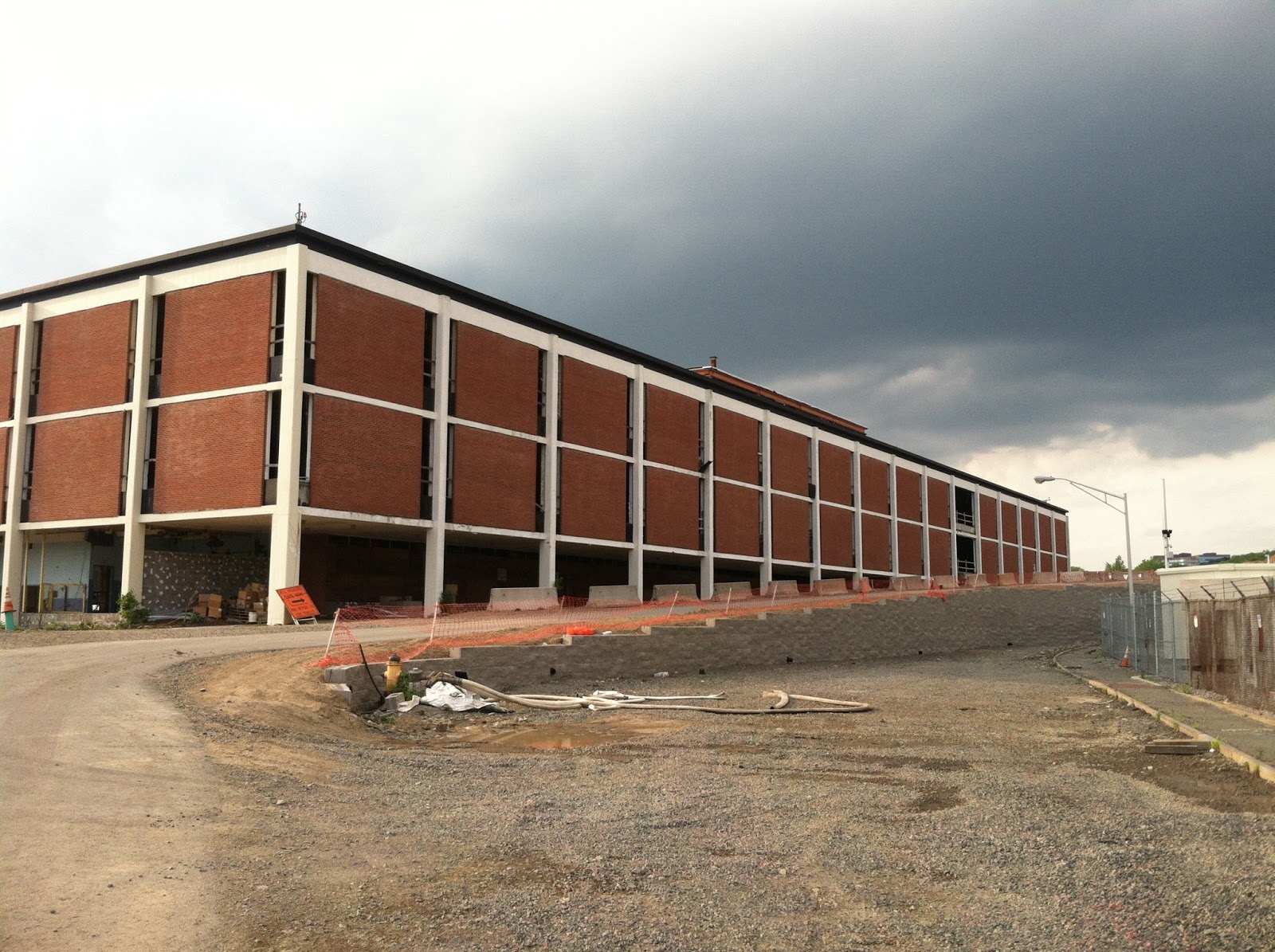
This week, Sean (another intern) and yours truly went on a tour of an abandoned Polaroid facility undergoing redevelopment.  If you drive by 1265 Main St. in Waltham, MA, the first thing you will notice is this giant shell of a building: (looking particular ominous under dark clouds).


This is the abandoned Polaroid factory, and the launch-off point for our tour.
Here are our tour guide gurus:


They are currently undergoing the ambitious effort of turning this abandoned Polaroid facility into a thriving space of offices and retail, with smarter ways of treating storm water.

In order to appreciate what they are doing, we have to first backtrack to the same site under the Polaroid regime.  During that time, large volumes of storm water would be flushed off the premises without undergoing important filtration processes.  As a result, pollutants attached to sediments would ultimately be discharged into the Charles River; which is bad news if you’re a fish – or anything that lives in, plays in, and depends on clean river water.

Because pollutants attach themselves to sediments (which are then washed into the River), a good way to tackle water pollution is to get a hold of the sediments before they can do their damage.  At 1265 Main St., different methods are utilized to do just that.  One way is by literally lining sewage drains with “blankets,” which collect particulates.  Another way is through wetland replications. Water flows slowly through wetlands, sediments settle, and plants uptake contaminants.  Wetlands do much of the dirty-work for us, and are scenic to boot!


In addition to these important methods of filtering pollutants, the 1265 Main St. team recycles materials produced during construction for other purposes, such as storm water management.  In order to level the site (which is currently on a gradient) so that new buildings can be built, the ground is blasted and giant piles of rocks of various sizes are produced.  There are currently so many piles of rocks that the site resembles a quarry – or in some parts, as one of the tour guides described, a Martian landscape.  Here is a storm water barrier recycled from a portion of these rocks.

  
Getting a sneak peak of this work-in-progress site was pretty cool – and I am excited to see how the site pans out.  I have just touched the tiniest surface of the construction efforts at 1265 Main St in this blog, and urge you all to check out their website (http://www.1265main.com/) for much more info and pics about the project.

Til next time!
Pam


Monday, May 20, 2013

More Than Just a Cleanup

On April 27th, thousands of volunteers came out to celebrate the beauty of the Charles River and help spruce it up for the beautiful months ahead. Almost a month later, I have had time to reflect on that day and what it means to me.

I first heard about the Charles River Earth Day Cleanup last April as a junior at Lesley University. One of my classes required a "do-it-yourself field trip" where students would attend an event and write a paper on it. I was familiar with the CRWA but had never worked with them on a project like this. I saw this as a golden opportunity to not only get a good topic for my paper but to also clean up the area where my friends and I would hang out. I told some of my classmates about this and the next thing I knew I was leading half the class to the Charles on April 21st, 2012. I ended up documenting the event and presented it to my class as my final project. I got an A and all was good.

Later, as I was searching for internships and I found that the CRWA was looking for new interns. I jumped on the opportunity to work for the group that put together such a fantastic event like the cleanup; I knew I wanted to be a part of it. And here I am, several months later in my last week of interning with the CRWA. It has been a very rewarding experience to work in the non-profit sector of Environmental Science. I'm most proud of how successful this years cleanup was. I had previously only experienced the cleanup as a volunteer but I had been given the opportunity to see it from the other side. I worked with the amazing CRWA staff to help organize this event and to see it go from tasks on a spreadsheet to volunteer-taken photos on our website has been truly memorable.

Being a part of such a meaningful event has made a lasting impression on me but the most impressionable aspect of the cleanup has been the volunteers that made this all possible. Thousands of volunteers took time out of their busy schedules and came together with one common cause: to clean up our beloved Charles. All it took was just three hours and we all helped to remove over 5 tons of garbage from our riverbanks. 5 tons in 3 hours!! Simply remarkable. So what does this say about us? Maybe it says that we're slobs that toss our trash out the window and forget about it. That we don't care or appreciate the natural beauty that is around us. Pessimists may think so, but not me. This event showed me that when we come together, we can do amazing things. In light of recent events, us Bostonians have had a renewed sense of camaraderie and community.  That spirit was put on display on April 27th when we put on our gloves, rolled up our sleeves, and restored one of the things that makes Boston so great. Our Charles River is certainly clean now, but we showed that we still love that dirty water.

Tuesday, May 14, 2013

Make Way for Herring

      What happens when humans and fish need to share a river? For thousands of years, humans have been altering the flow of rivers and streams to increase catches, create recreational water bodies, and generate power. When dams prevent fish like salmon and herring from migrating upstream to spawn, the fisheries suffer, along with the humans who depend on them. One way to prevent the loss of economically and ecologically valuable fish populations is to create a fish ladder alongside the dam. In theory, fish ladders provide safe passage for fish around the obstacle, allowing them to continue upstream.

      Fish ladders employ several strategies to make passage easier. Many dams create a quick change in elevation, so fish ladders will spread this change over a longer path, the same way that wheelchair ramps are longer and incline more gently than stairs. Water flowing through a dam may also be moving too fast, so fish ladders use structures such as weirs, baffles, and barriers that change how the water moves through the ladder. The aim of these structures is commonly to produce specific areas where water moves against the overall direction of flow, creating turbulence (Kamula, 2001). Turbulent water loses energy as it sloshes against itself, and overall flow velocity is reduced. Below are some different kinds of fish ladders.
www.dfg.ca.gov

commons.wikimedia.org
      The first image above shows a typical pool-and-weir fish ladder, while the second shows a larger ladder with some mid-stream structures designed to generate turbulence and simulate a natural stream flow.

      While there are a few basic types of fish ladder, hybrid styles and variations abound because each ladder must be built taking into account the size of the stream, its hydrology (such as natural seasonal variations in flow), and the species of fish that must make the passage. Some species, like salmon, are adapted to leap over rocks and through rapids, but others require slower water and gentle slopes. Different fishes also prefer to swim at different depths, but of course altering the depth of water in a ladder system changes how the water flows. You can see how designing a fish ladder can become complicated quickly. Ladders must also be easy to find: often the opening to the ladder is only a small fraction of the total width of the dam, and since many species naturally follow the fastest flow to get upstream (FAO), a poorly designed dam system may lead fish into a turbine outlet and away from the ladder. 

Watertown, MA : Watertown Dam
www.city-data.com

      Here on the Charles, the Watertown Dam (above) contains a fish ladder to allow herring and other species that spawn upstream to pass. The fish ladder is housed in the concrete structure seen at the far end of the dam. The dam currently serves no purpose (besides looking quite lovely), but while removal would certainly be the best option for spawning fish, concerns over polluted sediment trapped behind the dam make this unlikely for the moment.

      When Sean and I visited the dam more than a week ago, we did not see any fish attempting to use the ladder, though the large congregation of gulls directly below the dam suggested that fish were there. With any luck, over the next few weeks herring will begin to find the small outflow of the ladder, splash through the 10-15 chambers, emerge triumphant into the main stream, and give each other high-fives with their fins. Nice!


Fish Passages: Design, Dimensions, and Monitoring. Food and Agriculture Organization of the United Nations (FAO) and DVWK. 2002. Retrieved May 10 2013. 

Kamula, Rittaa. Flow over weirs with application to fish passage facilities. 2001. Retrieved May 10, 2013. http://herkules.oulu.fi/isbn9514259777/html/chapter1_2.html

What is a Fish Ladder and Weir? Michigan Department of Natural Resources. Retrieved May 10, 2013. http://www.michigan.gov/dnr/0,4570,7-153-10364_52259_19092-46291--,00.html.

Sunday, May 12, 2013

Intro to Ground Water


Water is an amazing and useful in every way a person can think of.  Living in Boston everyone at some point will take a walk near the Charles River. The river connects everyone from social events to business events along its way. Most people love to take part in activities such as walking, running, hiking, canoeing, fishing, ect… along the Charles. But these are only a small part of the river known as surface water that people actually see take part in and preserve.

Most people forget about groundwater. Ground water pumped from municipal wells supplies most of the drinking water used in the Upper Charles River Basin. "Ground water withdrawn from sand and gravel aquifers provides nearly all of the drinking water for a population of about 100,000 in eight towns in the Upper Charles River Basin (UCRB), which is in Eastern Massachusetts along the Interstate 495 corridor". For more information click on this link (http://pubs.usgs.gov/fs/fs-042-03/)

Groundwater is connected to the surface water through streams, ponds and wetlands. Therefore, withdrawals from ground water will have an effect on stream flow and the surface water in general that it’s connected to in many ways. It’s important to preserve and study both surface water and groundwater that so many people depend on; by doing so the information can help to guide water managements and regulation problems that many towns face, especially during the summer times. Therefore, organizations such as CRWA play a major role in persevering and studying water to help the environment and the people who depend on it. 


Mythreyi


Friday, February 22, 2013

Meet (and love) Charles Eliot!

It is easy to walk past a gray, engraved stone memorial on the Boston Esplanade without much thought.  The memorial is for Charles Eliot (1859-1897); a landscape designer, boyhood oddball, and – as it turns out – key contributor to the Charles River as we know it.                                          

File:Charles Eliot - Landscape Architect.jpg
Charles Eliot: the dude who we are talking about.
Growing up, Charles Eliot was somewhat of an awkward kid.  He was born to a family of great social reputation and wealth, (his father was the President of Harvard), but he himself was considered shy and fragile, more eager to sketch landscapes in his notebook than socialize with friends.  Worried for his son’s “melancholy withdrawals,” his father pressured Charles to gain strength of character through “strenuous life” activities, such as camping and sailing along the coast of New England.  Eliot soon organized and led a small band of Harvard peers that called themselves - in endearingly nerdy fashion - the “Champlain Society in scientific exploration of Mount Desert Island in Maine.”  Such experiences and his lifelong appreciation for nature’s beauty encouraged him to pursue a career in landscape architecture.

As a landscape architect, Eliot outlined three basic goals: to preserve scenery, make it accessible, and improve upon it.  He lobbied ceaselessly for the preservation of nature against commercial interests.  Eliot, whose birthright connected him to a circle of wealth and influence, was able to convince political industries to move industry back from the Lower Charles River.  He directed the early development of the Boston Metropolitan Park System, and published conceptual plans for the esplanades along the Charles River.  Thanks to his efforts, by 1900, streets and railroads had been relocated and the promenade had been built.

Eliot died at the shockingly young age of 37, but his ideas and passion for preservation paved the way for a protection of the land surrounding the Charles River and the park as we know it.  So now, I will think of him every time I see that stone memorial on the Esplanade.  Or better yet – when I take a fresh breath from the city, walk besides the Charles, and appreciate all that is still, thankfully, miraculously preserved :).

Til next time!
Pam